GOES and ABI Background
The Advanced Baseline Imager (ABI) instrument is one of six on the National Oceanic and Atmospheric Administration (NOAA) and National Aeronautics and Space Administration (NASA) GOES-R Series satellites launched since 2016. ABI is the primary instrument on the GOES-R Series satellites used for primarily imaging Earth's weather, oceans, and environment. Here, ABI data is used for a volcanic hazard application. ABI acquires data in 16 different spectral bands (compared to five on the previous generation of GOES), including two visible channels, four near-infrared channels, and ten infrared channels. The instrument is a multi-channel passive imaging radiometer designed to observe the Western Hemisphere and provide variable area imagery and radiometric information of Earth’s surface, atmosphere and cloud cover. ABI full disk scan mode provides an image of the entire disk every 10 minutes.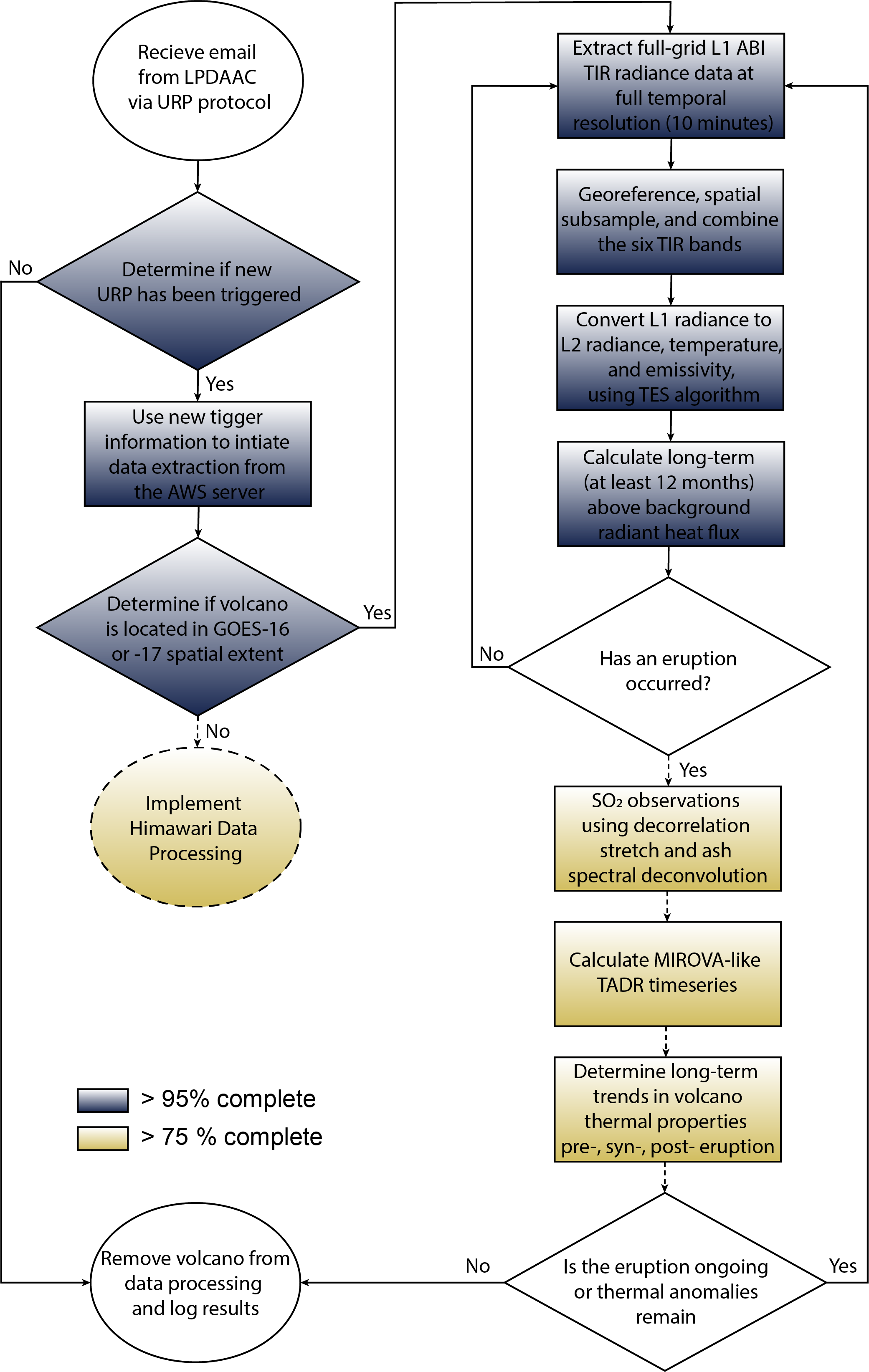
Figure 1. The GEO-URP automated processing workflow used to retrieve and analyze geostationary TIR data.

Figure 2. An example of the results of the spatiotemporal low pass filtering algorithms on the unprocessed geostationary TIR data.
GEO-URP Development
The Geostationary Operational Environmental Satellite Urgent Request Protocol (GEO-URP) System for Volcanic Observations was developed from the ASTER Urgent Request Protocol (URP) system (Figure 1). This original system was conceived in 2004 and implemented as a synergistic approach that would leverage ongoing operational volcanic monitoring programs that relied on high temporal/low spatial resolution satellites like AVHRR and MODIS to trigger (and eventually automate) the ASTER expedited data system (EDS), specifically for volcano monitoring and science (Ramsey, 2016). Over time, this protocol grew from a manual approach to an automated, successful global program since 2011 (Ramsey, 2016; Ramsey and Flynn, 2020).Once a volcano is identified as having an increased thermal output (i.e., "thermal anomaly"), tools developed for the URP Program are integrated to automatically retrieve, process, and analyze GOES ABI data. After the ASTER Emergency Scheduling Interface and Control System (AESICS) verifies the volcanic anomaly, the GEO-URP automated system spatial resamples 18 months of prior ABI full disk data from the AWS NOAA data server to a region around the triggered volcano. A 0.5 x 0.5° region around the volcanic summit is used to produce a statistically significant background removal value. The spatially resampled radiance data are separated into temperature and emissivity data products using a modified TES algorithm originally developed for ASTER (Gillespie et al., 1998). The data are then processed to remove scenes obscured by meteoric clouds, remove scenes with any non-volcanic anomalies, and establish baseline thermal fluctuations at the volcano. This processing, removal, and reduction uses spatiotemporal low pass filtering algorithms similar to the approach of Girona et al. (2021) (Figure 2), where:
- The removal of a 1-sigma percentile of low pass filter derived across a 3-month, 1- week, and, 6-hour interval.
- The removal of 2-sigma percentile background temperature values.
This allows an accurate calculate of the temperature above background trend and radiant heat flux (also known as radiant power). Timeseries analyses are then conducted to evaluate precursory and changing eruption activity.
The entire process from the initial trigger to timeseries analysis takes less than 5 days. However, after a volcanic eruption has been initially integrated into the system it is updated daily until the activity has subsided. This enables near real-time monitoring, modeling, and forecasting of lava and ash/SO2 plumes at high temporal resolution (e.g., Thompson et al., 2022).
Citations and Publications
Gillespie, A., Rokugawa, S., Matsunaga, T., Steven Cothern, J., Hook, S.J., Kahle, A.B., 1998. A temperature and emissivity separation algorithm for advanced spaceborne thermal emission and reflection radiometer (ASTER) images. IEEE Trans. Geosci. Remote Sens. 36, 1113–1126.
Girona, T., Realmuto, V., Lundgren, P., 2021. Large-scale thermal unrest of volcanoes for years prior to eruption. Nat. Geosci. 14, 238–241.
Ramsey, M. S., 2016, Synergistic use of satellite thermal detection and science: a decadal perspective using ASTER, Geological Society, London, Special Publications, 426 (1), 115-136.
Ramsey, M.S. and Flynn, I.T.W., 2020, The spatial and spectral resolution of ASTER infrared image data: A paradigm shift in volcanological remote sensing, Rem. Sens., 12, 738.
Thompson, J.O., Contreras-Arratia, R., Befus, K.S. and Ramsey, M.S., 2022. Thermal and seismic precursors to the explosive eruption at La Soufrière Volcano, St. Vincent in April 2021. EPSL, 592, 117621.
Williams, D.B. and Ramsey, M.S., 2022. Analysis of ash emissions from the 2020 Nishinoshima eruption using ASTER thermal infrared orbital data, Journal of Volcanology and Geothermal Research, 421.
Conference abstracts
Ramsey, M.S., Thompson, J.O., Leggett, T.N., Corradino C., 2021. Does data volume equate to better eruption forecasts? (invited), AGU Fall Meeting Abstracts, abs. V33C-01.
Realmuto, V.J., Prata, A.T., Ramsey, M.S., 2022. Combining geostationary and polar-orbiting observations of volcanic SO2 plumes: A case study from the June 2019 eruption of Raikoke Volcano, AGU Fall Mtg.
Thompson, J., Ramsey, M., Contreras-Arratia, R., 2021. Big pixel volcanic thermal activity, AGU Fall Meeting Abstracts, abs. A31B-05.
Thompson, J.O., Williams, D.B.*, Ramsey, M.S., Realmuto, V.J., 2022. Characterizing precursory volcanic activity using geostationary thermal infrared data, AGU Fall Mtg.
Williams, D.B., Ramsey, M.S., Thompson, J.O., 2021. Multiscale analysis of ash- and water-rich volcanic plumes using linear spectral deconvolution modeling, AGU Fall Meeting Abstracts, abs. V35E-0181.
Williams, D.B., Thompson, J.O., Ramsey, M.S., 2022. Modeling the composition and particle size distribution of the Hunga Tonga-Hunga Ha'apai ash plume using thermal infrared spectroscopy, AGU Fall Mtg.