|

[Future Work] [References] [Other Links] |
|
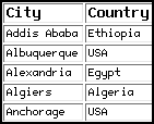
Table 1. Selected ASTER cities.
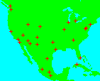
Figure 1. Location map of city targets.
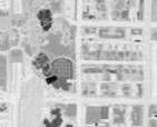
Figure 2. TIMS-derived night temperature image of Scottsdale, AZ.
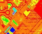
Figure 3. Color coded TIMS-derived night temperature image of Scottsdale, AZ.
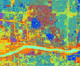
Figure 4. Maximum likelihood supervised classification of Phoenix, AZ.
|
The purpose of this ASTER Science Team
Acquisition Request (STAR) is to provide a dedicated observation strategy for urban
environmental monitoring around the world
(Table 1.).
The project will study 100 of the largest urban centers, with an emphasis on those
in arid and semi-arid environments (~ 75% of STAR request). The chosen cities
represent areas that are experiencing rapid growth and/or currently have populations
of approximately 1 million people
(Fig 1.).
The sites have been divided into high and low priority depending
on factors such as projected growth rates, potential urban/environmental hazards,
and successful ASTER observations (ie., low clouds). Studies will be done to
monitor urban growth, land use change, impact on the surrounding environment, and
the development of urban heat islands
(Fig 2.).
The Phoenix metropolitan area will be the site of a major effort using ASTER data (See, LTER project page). A NASA sponsored pilot project has been on-going for three years in conjunction with the City of Scottsdale, Arizona to study the use of thermal and visible/near-IR remotely sensed data for the purposes of urban scene classification, environmental assessment, and change detection. These data sets are being integrated into state and local activities to improve decision making and planning. In addition, the newly awarded Urban LTER sites include Phoenix, AZ and Baltimore, MD. These cities will be the focus of numerous ecological studies for the next decade. ASTER and other Mission to Planet Earth data will form a key component to this effort. Experience and data analysis models developed for these two regions can be exported to other cities that form this global data set. The primary application of remote sensing data in this study will be to provide a means for extrapolating detailed measurements at local sites to a regional context. Specifically, multi-spectral image classification will be used to identify land cover types, such as different grasses, crop, trees, soils, man-made materials, water, and native vegetation. When used with field validation, the current airborne and satellite data, as well as the future ASTER data will provide accurate identification and estimates of the areal distribution of different units [Ramsey, 2000; Stefanov, et al., 1998, 2000]. These data can then be used to create regional land use thematic maps that depict different processes. For example, urban versus native materials, permeable versus impermeable surfaces, and transportation systems (asphalt and concrete materials) can be mapped.
Currently, these classification algorithms and methodologies have been developed
and used in surface impermeability studies for storm runoff assessment. Specific test sites have included a section of the downtown
Scottsdale region that has been mapped in high detail as part of a pilot program to
develop an extensive GIS database. Tests sites also include the McDowell Mountains
immediately east of the city which are currently undergoing intensive study by
state and local agencies to assess potential sites for urban development as well as
preservation. These urban areas have provided excellent ground truth for the
validation of the surface classification models and contain a time history of the
expansion of the urban areas into pristine desert. A second example of the
application of remote sensing is the use of temperature maps derived from thermal
data to study the spatial distribution of heat islands
(Fig 3.).
and monitor their changes over time with changing land use and urban growth.
This project will acquire ASTER data over each city at least twice per year (both day and night observations) during the lifetime of the mission [Ramsey et al., 1999]. Initially, data of Phoenix and the surrounding area will be used to aid in the LTER research effort. Already underway, classification algorithms are being developed for Landsat data of the region in order to study temporal and spatial scale changes (Fig 4.). These will be extended to ASTER data of Phoenix and subsequently the other cities that form the STAR. Additionally, contact efforts will be initiated with government officials of the other cities and data will be stored at ASU and available for use by interested parties. Finally, airborne, high spatial resolution MASTER data has been collected over the entire Phoenix metropolitan region as well as Los Angeles, CA. These data contain 50 spectral bands and can be used to simulated ASTER data with the added possibilities of hyperspectral science [Ramsey and Stefanov, 2000].
Ramsey, M.S., Mapping the City Landscape From Space: The Advanced Spaceborne Thermal Emission and Reflectance Radiometer (ASTER) Urban Environmental Monitoring Program, in Earth Science in the City, G. Heiken, R. Fakundiny, J. Sutter, (eds.), Am. Geophys. Un. Press, Washington, D.C., 337-361, 2003. Stefanov, W.L., M.S. Ramsey, and P.R. Christensen, Monitoring the urban environment: An expert system approach to land cover classification of semiarid to arid urban centers, Rem. Sens. Environ., 77:2, pp. 173-185, 2001. Ramsey, M.S., and W.L. Stefanov, The Advanced Spaceborne Thermal Emission and Reflectance Radiometer (ASTER) Urban Environmental Monitoring program: Local results using airborne MASTER data from Phoenix, AZ, Invited (MASTER special session): ERIM 14th Appl. Geol. Rem. Sens. Conf., Nov., 2000. Stefanov W.L., Ramsey, M.S., and P.R. Christensen, Monitoring urban land cover change: An expert system approach to land cover classification of the Phoenix metropolitan area, in Abs. of the Ecol. Soc. Am. Ann. Mtg., pp. 387-388, 2000. Stefanov, W.L., P.R. Christensen and M.S. Ramsey, Remote sensing of urban ecology at regional and global scales: Results from the Central Arizona-Phoenix LTER site and ASTER urban environmental monitoring program, Regensberger Geographische Schriften 35, (plus suppl. CD-ROM), pp. 97-98, 2001. Ramsey, M.S., Mapping the City Landscape From Space: The Advanced Spaceborne Thermal Emission and Reflectance Radiometer (ASTER) Urban Environmental Monitoring Program, Invited (U01: Earth Sciences in the Cities special session): Am. Geophys. Union EOS Transactions, 81:19, p. S11, 2000. Ramsey, M.S., W.L. Stefanov, and P.R. Christensen, Monitoring world-wide urban land cover changes using ASTER: Preliminary results from the Phoenix, AZ LTER site, in Proc. of the 13th Appl. Geol. Rem. Sens. Conf., Vancouver, BC, Canada, v. 2, pp. 237-244, 1999. Stefanov, W.L., P.R. Christensen, and M.S. Ramsey, 1998, Mineralogic analysis of soils using linear deconvolution of mid-infrared spectra, Geol. Soc. Am. Abst. with Progs., v. 30, no. 7, p. A138, 1998.
|