|
[Future Work] [References] [Other Links] |
|
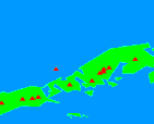
Figure 1. Location map of Eastern Aleutian targets.
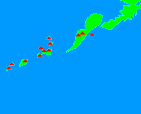
Figure 2. Location map of Western Aleutian targets.
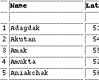
Table 1. Selected Aleutian targets.
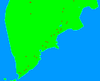
Figure 3. Location map of Kamchatkan targets.
Table 2. Selected Kamchatkan targets.
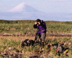
Figure 4. Field Work on Unimak Island.
|
The purpose of this STAR is to provide a dedicated ASTER observation strategy for the Aleutian (Fig 1 - Fig 2) and Kamchatkan Arc (Fig 3) volcanoes. The data acquired will become an integral part of the ongoing Alaska Volcano Observatory's monitoring program using AVHRR [Dean et al., 1998; Harris et al., 2000]. In addition, volcano targets for the Northern Pacific will be integrated into the larger Global Volcanism STAR so as not to result in any duplicated effort from the numerous volcanic investigations using ASTER. The need for a dedicated monitoring and mapping strategy for the Aleutians is critical for several reasons. Most importantly is the mitigation of volcanic plume hazards for airline passenger safety. The northern trans-Pacific corridor is the most heavily traveled airline route in the world. The use of ASTER to detect thermal anomalies and monitor volcanic plumes will greatly improve current efforts using the lower resolution AVHRR instrument. ASTER will also provide high spatial and moderate spectral resolution data of the numerous remote volcanoes that form the Aleutian Arc. Many of these sites have only been sampled in the past with no geologic or hazard mapping done. Finally, eruption detection and monitoring will greatly benefit the the peoples of Alaska as well as populations living in the path of the future plumes. This observational strategy seeks to acquire ASTER data over the entire volcanic chain as well as Kamchatka as many times as possible during the lifetime of the mission (see, Table 1 and Table 2). Realizing that this is a large request for 117 sites, we have prioritized the locations and chose 22 of the recently active volcanoes for the most intensive study (as often as possible with both day and night observations). In addition, sites will be more actively imaged in the summer months, when snow melt will allow many to be geologically mapped. To this end, two of the sites, Mt. Augustine and Shishaldin have already been approved for ICO observations. Mt. Augustine is one of the top 22 sites and poses immediate tsunami hazards to Anchorage and surrounding towns in the Cook Inlet if a large eruption takes place.
We are currently developing new multi-frequency, multi-temporal satellite remote sensing tools, using data from ASTER (Advanced Spaceborne Thermal Emission and Reflection Radiometer), SRTM (Shuttle Radar Topography Mission), and SAR, for use in investigating the types of volcanic eruptions and associated hazards that occur in the Aleutian Volcanic Arc [Ramsey and Fink, 1999, 2000; Wessels and Ramsey, 2000]. To develop such tools, we are focusing an integrated geologic and remote sensing survey of the volcanic deposits and hazards on three Unimak Island volcanoes: Shishaldin, Fisher, and Westdahl (Fig 4). Unimak Island is the most active volcanic center in the Aleutians, and these volcanoes are typical of those in the Aleutians, thus serving as type examples for Aleutian volcanic hazards. In addition, Fisher Volcano collapsed as a caldera, sending large volume pyroclastic flows into the Pacific Ocean and Bering Sea. Many such caldera eruptions have occurred in the Aleutains, and their hazards would be devastating to the entire North Pacific Rim. Our integrated study of the Unimak Island volcanoes will also serve to calibrate data from ASTER and SRTM for wide range of volcanic deposits, rock types, landforms, and hazards. This will allow the use of these invaluable techniques for mapping and identifying volcanic deposits and hazards on more remote Aleutian Island volcanoes, where the benefit of field calibration will not be available. It is critical to understand and mitigate the types of volcanic hazards that occur in the Aleutians, as they directly influence activity in the North Pacific air routes, which carry 20,000 passengers per day and most of the air cargo between eastern Asia and North America, as well as the major international fishery in the North Pacific and Bering Sea and one of the busiest seafood ports in the United States, Dutch Harbor [Casadevall, 1994].
Collected data will initially be examined at the University of Pittsburgh, JPL, and AVO. Plans are underway to form a direct link to the Alaska Volcano Observatory now. In this way, data can be placed into the hands of the scientists most directly involved with Aleutian volcano monitoring.
Ramsey, M.S. and Dehn, J., Spaceborne observations of the 2000 Bezymianny, Kamchatka eruption: The integration of high-resolution ASTER data into near real-time monitoring using AVHRR, J. Volc. Geotherm. Res., (in review), 2003. Ramsey, M.S. and J. Dehn, The 2000 eruption of Bezymianny Volcano captured with ASTER: A proposal to integrate high-resolution remote sensing data into real-time eruption monitoring at AVO, in Proc. of the 3rd Ann. Subduction Processes in the Kurile-Kamchatka-Aleutian Arcs, p. 44-45, 2002. Ramsey, M.S., and D.C. Pieri, INVITED: Monitoring, Assessment and Mitigation of Volcanic Hazards Using the Spaceborne ASTER Instrument, Geol. Soc. Am. Abs. with Programs, v. 34, p. 242, 2002. Casadevall, T.J., The 1989-1990 eruption of Redoubt Volcano, Alaska: Impacts on aircraft operations, J. Volcanol. Geotherm. Res. v. 62, pp. 301-316, 1994. Dehn, K.G., Servilla, M., Roach, A., Foster, B., Engle, K., Satellite Monitoring of Remote Volcanoes Improves Study Efforts in Alaska, EOS, Trans. Amer. Geophys. Union, v. 79, n. 35, p. 413 & 422-423, 1998. Harris, A. J., et al., Real-time Satellite Monitoring of Volcanic Hot Spots, in Mouginis-Mark, P.J., Crisp, J.A. and Fink, J.H. (Eds), Remote Sensing of Active Volcanism, Geophysical Monograph Series, Vol. 116, 274 pp., 2000. Ramsey, M.S., and Fink, J.H., Hazard Mitigation Associated with Silicic Dome Emplacement: Monitoring Surface Textural Variations Using Remote Sensing, in Abstr. of the Gen. Assembly IAVCEI, p. 234, 2000. Ramsey, M.S., and Fink, J.H., Estimating Silicic Lava Vesicularity with Thermal Remote Sensing: A new Technique for Volcanic Mapping and Monitoring, Bull. Volc. 61, pp. 32-39, 1999. Wessels, R. and Ramsey, M.S. Multi-sensor/Multi-wavelength Data Fusion Over Steep Volcanic Terrain: Analysis Challenges in the Next Era of Remote Sensing, Am. Geophys. Union EOS Transactions, 81:48, p. F1255, 2000.
|