|
 [Future Work] [References] [Other Links] |
|
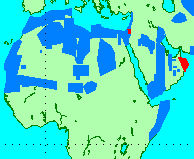
Figure 1. Location map of desert targets.
Table 1. Selected high- priority desert targets.
Table 2. Selected low-priority desert targets.
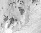
Figure 2. Location image of the Kelso Dunes sand transportation pathway.
Figure 3a. Surface emissivity image.
Figure 3b. Surface temperature image.
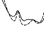
Figure 4. Emission spectra and best-fit of Kelso sand sample.
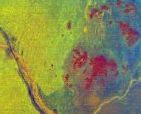
Figure 5. Three-color endmember composite image. |
I. Project Overview
The purpose of this ASTER Science Team Acquisition Request (STAR) is to provide a dedicated instrument observation strategy for the global deserts, arid regions, and locations especially prone to potential desertification. In arid regions throughout the world, the geologic processes of weathering, sediment transport, and deposition are constantly ongoing within active sand transport pathways. The analysis of dune field composition and movement are critical for the interpretation of past climatic conditions, local geology, and future desertification potential. This planned observation strategy is to acquire one-time and repetitive ASTER data over much of the world's deserts and arid regions (Fig. 1). Because of the size of the data request, the targets have been split into low (Table 1.) and high (Table 2) priority targets [Ramsey and Lancaster, 1998]. The high priority sites have been chosen in consultation with an newly established world-wide network of field investigators. Currently, contacts are in place between the University of Pittsburgh and the Desert Research Institute (DRI) in Reno, Nevada; the University of Cape Town in South Africa; Ben-Gurion University in Israel; and the Federal University of Ceara, in Brazil. This network will be expanded in the future. The current target sites are concentrated in Brazil, Namibia, South Africa, and the southwestern United States/northern Mexico. These locations have been the target of many years of active research into the ongoing processes of land degradation and sand encroachment. For these highly monitored sites, ASTER data will be requested for up to two times per year in order to correlate seasonal changes measured on the ground to those captured with orbital data. Ground observations will be coordinated with ASTER overpasses for these locations. The larger (lower priority) global deserts targets will be requested only once during the life of the mission. These targets will be compared with MODIS data sets and used for large-scale examination of dune morphology and determination of the active sand transport pathways. It is expected that for many of the large global sand seas, examination at ASTER spectral and spatial scales will provide new insights into paleoclimates of the region. II. Ongoing Research The use of remote sensing over the past several decades as a tool to study dynamic features such as dunes has given the geologist a synoptic view of the entire field as well as it sources. In addition, the ability to examine changes over time allows for the extrapolation of current climatic regimes and the monitoring of marginal areas susceptible to future desertification. TIR remote sensing can provide the geologist with a synoptic look at an entire eolian system over different time scales, allowing an inference of past activity and the monitoring of current climate changes. Drought-prone areas on the metastable margins of these transport pathways and sand seas are easily susceptible to dune encroachment and possible desertification with environmental change. Human activity in these regions around the globe will benefit from repetitive monitoring programs using ASTER data in conjunction with analysis techniques such as linear deconvolution. An ongoing research project at the Kelso Dunes, eastern Mojave Desert, California (Fig. 2) is being used as a test locale to examine the ability to identify mineralogy and trace sand migration with time [Ramsey and Christensen, 1997; Ramsey and Lancaster, 1998]. To date, the research has utilized airborne Thermal Infrared Multispectral Scanner (TIMS) data, however plans are in place to perform similar studies using ASTER and eventually export the methodology to other global targets. The Kelso dune field is located at the terminus of a sand transport pathway, which has its primary source at the Mojave River Wash 50 km to the west. Initial examination of 1984 airborne TIMS data showed significant spectral variations that indicate potential mineralogic heterogeneities within the active dunes. This result prompted the collection of a suite of 48 sand samples in 1990, and new TIMS data to be acquired in 1995. This new data set was separated into surface emissivity (Fig. 3a) and brightness temperature (Fig. 3b) with the emissivity data used to test a newly-developed linear spectral retrieval algorithm in conjunction with a spectral library of endmember minerals. Results of this analysis produced images of endmember minerals which showed marked variations within the dunes. In addition, standard petrographic techniques revealed that the dunes did contain mineralogic variations and were much less quartz-rich (~ 42%) than previously reported (~ 70-90%). Point count results agreed with the spectral data to within an average of 5.3% for the TIMS-derived and 3.1% for laboratory-derived mineralogic abundances (Fig. 4). High concentrations of several of the endmember minerals on the surrounding alluvial fans indicate a potential near source for these minerals. Most evident is the presence of potassium feldspar from the fan that emanates from the Providence Mountains east of the dunes (Fig. 5). This previously unidentified potential sand input is not visible with other remote sensing techniques and was confirmed with additional field sampling. Much of the quartz and some plagioclase feldspar, on the other hand, appears to have been transported from the Mojave River Wash source as previously reported. This study also validates the potential of using thermal remote sensing from satellite-based instruments such as ASTER to globally monitor desert fringe areas susceptible to sand encroachment with changing conditions. III. Future Work Collected data will initially be examined at the University of Pittsburgh and DRI by the co-investigators of this proposal. Plans are underway to form a direct link to the field sites. Processing, examination, and monitoring of changes eventually will transition over to the home institutions of the scientists using the ASTER data. However, it is expected that the IVIS Laboratory, University of Pittsburgh and DRI will continue to act as the primary users and contacts between the ASTER mission and the foreign scientists. Plans are underway to establish a series of semi-permanent field stations to collect atmospheric and spectral data during satellite over passes. IV. References Ramsey, M.S., and N. Lancaster, Using remote sensing to derive sediment mixing patterns in arid environments: Future global possibilities with the ASTER instrument, Geol. Soc. Am. Abst. with Progs., v. 30, no. 7, p. A360, 1999. Ramsey, M.S., P.R. Christensen, N. Lancaster, and D.A. Howard, Identification of sand sources and transport pathways at the Kelso Dunes, California using thermal infrared remote sensing, Geol. Soc. Amer. Bull., 111, pp. 646-662, 1999. Ramsey, M.S., and P.R. Christensen, Monitoring potential desertification via airborne TIR data: Sediment transport in the Mojave Desert, California, The First JPL Workshop on Rem. Sens. of Land Surface Emissivity, Pasadena, CA, (to be published), 1997.
|