|

[Facilities] [REES] [References] [Other Links] |
|
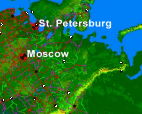
Figure 1. Location map of city targets.
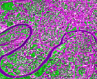
Figure 2. SPOT imagery of Moscow.
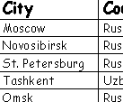
Table 1. Selected FSU cities.
|
For a decade, the region that included the former Soviet Union (FSU) and the states of Central and Eastern Europe (Fig. 1) has been undergoing fundamental and, at times, tumultuous change. Societies are being transformed, and economic and political systems are being rebuilt under a variety of models and conditions. With the current fiscal condition of Russia and the other FSU countries, both ecological and environmental problems within the urban population centers are commonly overlooked. ASTER data will be important in addressing these problems because it will provide information from visible to thermal infrared wavelengths for the first time. This will allow detection of man-made, geological and biological ground cover. By combining the unique strengths of Department of Geology and Planetary Science (G&PS) and the Russian and East European Studies (REES) Program at the University Of Pittsburgh, we propose to analyze high-resolution multispectral ASTER data from selected cities in the former Soviet Union and to develop spatially accurate geographic information system (GIS) urban and regional coverage (Fig. 2). Our principal goals are to develop urban scene classification, environmental assessment and to begin a program of change detection of these major urban centers.
We would like to augment the already existing ASTER UEM Science Team Acquisition Request (STAR). Currently, there are three FSU urban centers (Moscow, Novosibirsk and St. Petersburg) as part of the this request, however all are listed as low-priority targets. It is our understanding that this status means data acquisition of one or two times per mission. This will be insufficient for the purposes of this study and we therefore propose to elevate those three cities to high priority (one time/year) as well as add four new urban centers (Table 1.). Because of the University's unique position of having both the scientific expertise and the foreign relations personnel, we will be able to analyze the ASTER data and share it with our Russian colleagues who are challenged with these urban environmental issues. ASTER data will provide both a scientific and political outreach tool that could have far-reaching results.
Within the Department of Geology and Planetary Science we have developed expertise in computational manipulation of spatial data (remote sensing/image processing and GIS) and presently offer the University's Geographical Information Laboratory and Certificate. GPS is responsible for teaching courses in geology, planetary science, geography, GIS, and remote sensing. We offer undergraduate degrees in Geology (B.S.), Environmental Geology (B.S.), and Environmental Studies (B.A.), as well as Master (M.S.) and doctorate (Ph.D.) degrees in Geology and Planetary Science. The Department of G&PS presently maintains hardware resources, including 10 SPARC station IPX, SUN SPARC 4/75 GX, SPARC 5, ULTRA-1, ULTRA-2, 2 SUN3/80, SUN 3/60 and a SGI Indigo workstation. Within the next year, we will add a state of the art VNIR-TIR spectroscopy laboratory and a Unix/NT remote sensing processing facility. Current supported software includes Arc/Info 8.0.1, Arc/View 3.2a, ERDAS Imagine 8.3, ERDAS Virtual GIS 8.4, and ER Mapper 5.6, ENVI 3.2 and IDL. Within GPS a dynamic map server is maintained for the visualization of both raster and vector datasets utilizing ESRI MapObjects, Microsoft Visual Developers Studio Visual BASIC, and Visual C++ computer languages.
Established in 1965, the Center for Russian and East European Studies is designated by the U.S. Department of Education for Title VI funding as a National Resource Center. This distinguishes REES as one of the nation's strongest language and area studies centers. The center plays an important role in the University's international mission by providing educational enrichment to and drawing on the resources of individuals as well as the ethnic and corporate communities in Pittsburgh, Western Pennsylvania, and nationwide. The 57 faculty affiliated with REES are based in 16 different arts and sciences departments and in seven professional schools.
Ramsey, M.S., Mapping the City Landscape From Space: The Advanced Spaceborne Thermal Emission and Reflectance Radiometer (ASTER) Urban Environmental Monitoring Program, Earth Science in the Cities - AGU Special Monograph (in press), 2003. Stefanov, W.L., M.S. Ramsey, and P.R. Christensen, Monitoring the urban environment: An expert system approach to land cover classification of semiarid to arid urban centers, Rem. Sens. Environ., 77:2, pp. 173-185, 2001.
|