IVIS Laboratory
Image Visualization and Infrared Spectroscopy Lab
Prof. Michael S. Ramsey (Director)
Home
▼ Current Projects ▼
Data Archives
▼ Laboratories ▼
Links
Personnel
Publications
University of Pittsburgh

Project Archive
The ASTER Urgent Request Protocol System for Volcanic Observations
Funding Agency/Program:
- NASA, The Science of Terra and Aqua Program
Principal Investigator: Dr. Michael Ramsey
Overview
Monitoring of volcanic processes from orbit using thermal infrared (TIR) data has been ongoing from the earliest days of the satellite era. The Advanced Spaceborne Thermal Emission Radiometer (ASTER) instrument is one of five on the National Aeronautics and Space Administration (NASA) Terra satellite launched in December 1999. The instrument continues to operate and has acquired over 3 million scenes in 16 years, with nearly 10% of those focused solely on volcanoes and volcanic activity. Among the innovative tools created for this complex imaging instrument, was the expedited data system (EDS). The EDS is a scheduling and processing plan initially designed to reduce the time required to rapidly schedule and image a high priority target. It was envisioned as a manual-only system to be used in situations requiring a rapid response.
The ASTER Urgent Request Protocol (URP) system was conceived in 2004 and implemented as a synergistic approach that would leverage ongoing operational volcanic monitoring programs that relied on high temporal/low spatial resolution satellites like AVHRR and MODIS to trigger (and eventually automate) the ASTER EDS, specifically for volcano monitoring and science. The concept was to create a sensor-web approach to capture the higher spatial and spectral resolution ASTER data of new volcanic activity as quickly as possible. Over time, this protocol grew from a manual approach to an automated, successful program in the North Pacific region and eventually to the third, global phase using MODIS data as the trigger for ASTER. This phase of the URP system has been operational since 2011.
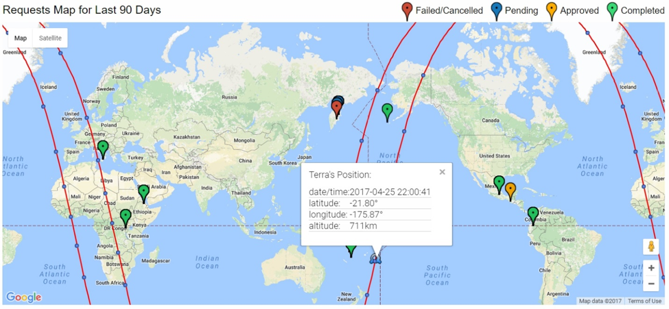
Once a volcano is identified as having an increased thermal output (i.e., “thermal anomaly”), tools developed for the URP Program provide this rapid pathway for scheduling, collecting and processing of the ASTER data. For example, an automated software system at the Land Processes Distributed Active Archive Center (LP DAAC) called the ASTER Emergency Scheduling Interface and Control System (AESICS) handles that request, verifies that there are no prior ones in the queue, and if not, formats and forwards an ASTER schedule request, lastly updating the database (Figure 1). The entire process from the initial trigger to awaiting final scheduling approval takes less than 5 minutes. However, the actual schedule planning and transmission can take from several hours up to 1 day, because that remains manual. Data are typically acquired as quickly as 24 hours up to several days depending on the orbit track of Terra at the time. Finally, within 2 - 4 hours of the data being acquired, all scientists involved are automatically notified and have immediate web-based access to the new scene.
The long-term URP program has funded graduate student research, supported several international field campaigns to active volcanoes, as well as aided in the development of new software tools such as AESICS. Another innovative educational component of the URP Program has been the Ph.D. in Residence initiative. This provides the resources for Ph.D. students to spend several years of their research at collaborating URP universities around the world. The students have the opportunity to take coursework and undertake research with volcanologists and remote sensing researchers at these schools.
Ongoing Research
The original objective of the URP program, to acquire data quickly of new activity, has been highly successful. These observations have provided remarkable data in the early phases of volcanic eruptions around the globe, including precursory thermal activity, emplacement of new lava flows, and detection/compositional analysis of plumes (Figure 2). Perhaps more importantly, is that the URP request remains active as long as thermal alerts are being recorded by AVHRR or MODIS. This has provided an unprecedented time series of high-spatial resolution visible and thermal infrared data for numerous volcanoes. With such data comes the ability to track lava flow emplacement rates, view continued periods of ash and ash flow deposition, as well as detect low-grade thermal precursory activity that precedes some eruptions by weeks to months.
The ongoing research of the URP program is focused on mining this decade-plus archive while observing all activity from the new data continually being acquired. At higher latitudes such as the volcanoes in Kamchatka, ASTER can acquire data as frequently as every 1-3 days providing unique day-night-day observations (Figure 3). During long eruptions, this frequency results in an archive of dozens to hundreds of scenes. There has never been data acquired of volcanic activity at this temporal and high spatial resolution, which has also allowed studies into rates of cloud cover and average detection/observation rates in order to plan for future orbital sensors.
The archive is being mined for other longer-term studies of volcanic cyclical behavior, arc-wide integrative studies, and documenting subtle precursory activity.
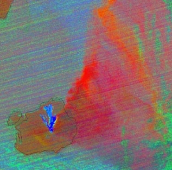 Figure 2. ASTER URP observation of the eruption of Mt. Augustine, Alaska in January, 2006 (nighttime TIR decorrelation stretch highlighting the plume with ash shown as red, SO2 in yellow and orange indicating an equal mix of both.
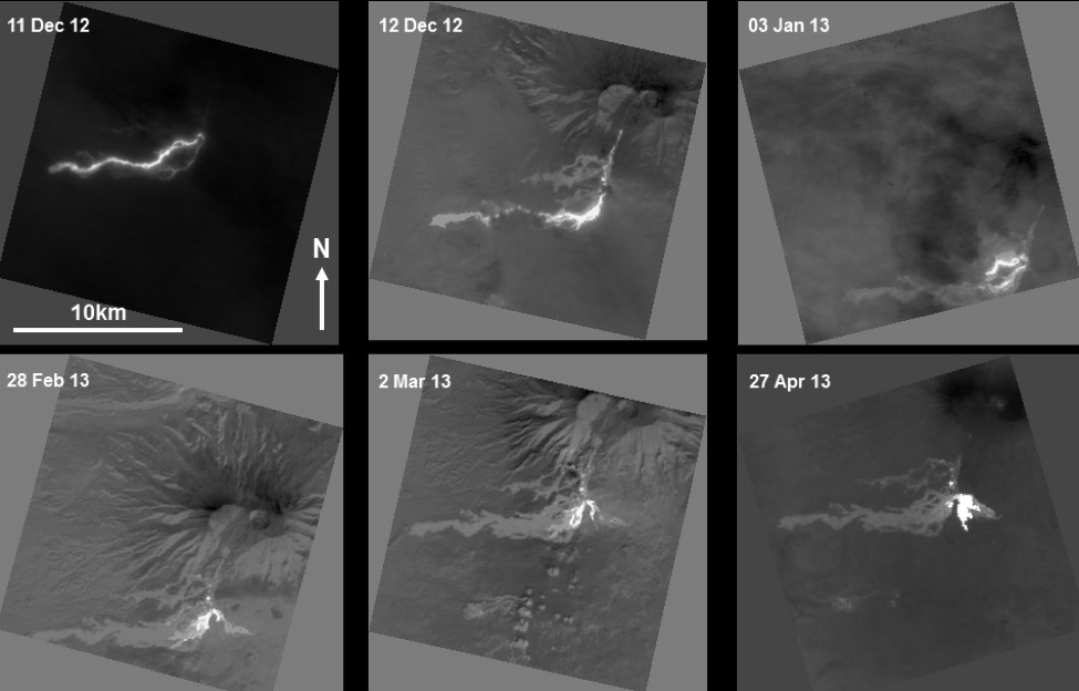 Figure 3. ASTER URP observations of the eruption of Tolbachik volcano, Russia from 2012 – 2013. TIR data show the progression of the basaltic lava flows and creation of the flow field.
Future Work
Plans are underway for Phase 4 of the URP. Currently, the limited number of MODIS-observed targets (17 on average), plus the continued AVHRR URP monitoring of the entire North Pacific region, consistently produces expedited requests at or near the maximum monthly limit for ASTER (Figure 4). The primary goal is to find creative ways to collect more data more rapidly at more volcanoes. One straightforward way to do this is to relax the previously agreed upon limit of 30 EDS scenes each per month from the United States and Japan, which represents only approximately 0.33% of the average ASTER volume collected in a given month.
Phase 4 will also focus on integrating new high-temporal resolution sensors into the triggering algorithm, experiment more with ASTER’s observational strategy and resources in the latter years of the instrument and finally, incorporate new high spatial resolution sensors into the URP as the ASTER mission finally ends.
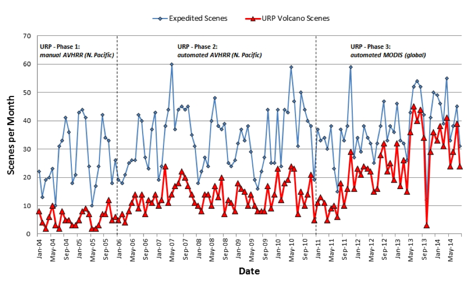 Figure 4. United States ASTER Science Team expedited scenes (solid line) and URP scenes (dashed line) per month beginning at the start of the URP project in 2004 and showing the three phases of the project. During those phases, the URP data increased from an average of 21.6% to 40.0% to 61.0% of the total expedited data collected by the United States Team, which attests to the success of the URP project.
Products
Duda, K.A., Ramsey, M., Wessels, R. and Dehn, J., Optical satellite volcano monitoring: A multi-sensor rapid response system. In Geoscience and Remote Sensing; Ho, P.P., Ed.; IN-TECH Press: Vukovar, Croatia, 473-496, 2009.
Ramsey, M.S., Results of increased spatial and spectral observations of volcanic activity: Implications for HyspIRI TIR data, 2012 HyspIRI Science Symposium, Greenbelt, MD, 2012.
Ramsey, M.S., Implications of temporal and spectral resolution changes for HyspIRI TIR data of volcanoes, 2012 HyspIRI Science Workshop, Washington, DC, 2012.
Ramsey, M.S., Reath, K.A. and Williams, D.B., Threshold considerations for future volcanic hotspot and ash detection using HyspIRI, 2013 HyspIRI Science Workshop, Pasadena, CA, 2013.
Ramsey, M.S., Reath, K.A. and Williams, D.B., Threshold considerations for future volcanic hotspot and ash detection using HyspIRI, 2013 HyspIRI Science Workshop, Pasadena, CA, 2013.
Ramsey, M.S., Synergistic use of satellite volcano detection and science: A fifteen year perspective of ASTER on Terra, abs. GC51E-0479, presented at AGU Fall Mtg., 2014.
Ramsey, M.S. and Harris, A.J.L., Volcanology 2020: How will thermal remote sensing of volcanic surface activity evolve over the next decade?, J. Volc. Geotherm. Res., 249, 217-233, 2014.
Ramsey, M.S., Synergistic use of thermal infrared field and satellite data: Eruption detection, monitoring and science, Geophys. Res. Abs., vol. 17, abs. EGU2015-9121, EGU General Assembly, 2015.
Ramsey, M.S., Synergistic use of satellite thermal detection and science: A decadal perspective using ASTER, Detecting, Modelling and Responding to Effusive Eruptions, in: Harris, A.J.L., De Groeve, T., Garel, F. & Carn, S.A. (eds.), Detecting, Modelling and Responding to Effusive Eruptions, Geol. Soc., London, Special Publications, 426, doi:10.1144/SP426.23, 2015.
Reath, K.A., Dehn, J. and Ramsey, M.S., Combining high temporal and high spatial resolution thermal infrared datasets to detect volcanic precursors, abs. V43B-2891, presented at the AGU Fall Mtg., 2013.
Reath, K.A., Wright, R.W. and Ramsey, M.S., ASTER/AVHRR Data Hybridization to determine Pyroclastic Flow cooling curves, abs. V41B-4805, presented at AGU Fall Mtg., 2014.
Reath, K.A., Ramsey, M.S., Dehn, J., Webley, P.W., Predicting eruptions from precursory activity using remote sensing data hybridization, J. Volcanol. Geotherm. Res., 321, 18-30, 2016.
Wessels, R.L., Schneider, D.J., Coombs, M.L., Dehn, J. and Ramsey, M.S., High-resolution satellite and airborne thermal infrared imaging of the 2006 eruption of Augustine Volcano, Alaska, in The 2006 eruption of Augustine Volcano, Alaska, Power, J.A., Coombs, M.L. and Freymueller, J.T., (eds.), U.S. Geological Survey, Professional Paper #1769, 527-553, 2010.
Williams, D.B., Ramsey, M.S. and Karimi, B., Identifying the volcanic source of disconnected ash clouds using the HYSPLIT dispersion model, AGU Fall Mtg., 2013.
Williams, D.B. and Ramsey, M.S., Analyzing proximal volcanic ash emissions using high spatial resolution thermal infrared imagery, Tephra 2014 Meeting: Maximizing the potential of Tephra for multidisciplinary science, Portland, OR, 2014.
Williams, D.B., Ramsey, M.S., Wickens, D.J. and Karimi, B., Identifying eruptive sources of drifting volcanic ash clouds using back-trajectory modelling and satellite data, Bull. Volc., (in preparation).