|
[Future Work] [References] [Other Links] |
|
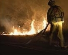
Figure 1. Brush fire near San Diego, CA threatens homes.
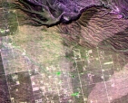
Figure 2. SIR-C multi-frequency color composite of the Cave Creek, AZ fire scar.
Figure 3. First ASTER image of the Phoenix fire scar study region.
Figure 4. Balloon digital areal photographic mosaic of fire scar.
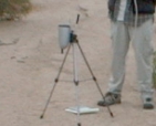
Figure 5. Acquisition of VNIR field spectra at the Cave Creek, AZ fire scar.
|
The summer of 2000 was the worst fire season in the past 50 years for the western United States. As of early September, over 6.5 million acres had burned and the cost of fighting the fires is expected to top one billion US dollars. The large Los Alamos, NM fire and numerous smaller fires in the drought-stricken southwest attest to the hazards of desert brush fires. Further, the fire season has been more severe and lasted far longer than past years as evidence by the January, 2001 Viejas Fire east of San Diego, CA (Fig. 1). Brush fires also have the potential to instigate hazards years after the fire has been extinguished. The removal of vegetation in these scar regions may facilitate rapid flood run-off and soil erosion over the next several monsoon seasons. It is important to better understand these dangers in light of the rapid increase in urbanization and population in cities throughout the southwest and in similar environments around the world. Factors that influence the formation and location of these fire scars are varied, but commonly include: the proximity of human activity, short and long term climate variations, and vegetation type and abundance. Remote sensing imagery of the urban environment and surrounding regions in the southwestern US reveals the presence of old brush fire scars dating back 30-50 years. Depending on the wavelength region examined, the age and surface properties of the scars can be determined. A pilot study is now underway examining historic data from the Landsat TM, SIR-C radar, and airborne thermal infrared scanners of existing brush fire scars surrounding Phoenix, AZ (Fig. 2). This stage investigates the linkage between the fire scar age, vegetation type/recovery, soil type and local topography. That information can then be used to model surface response to heavy rainfall and assess the potential for future flood and fire hazards. The following stage will be to translate these findings to newly-acquired ASTER data over Phoenix, AZ assessing its utility in fire scar detection. Finally, models and algorithms developed will be applied to ASTER data from cities around the world (see the ASTER UEM project page) [Ramsey, 2001].
We have noted, based upon preliminary observations of several generations of brush fire scars surrounding Phoenix that the disappearance of the scar occurs first in the reflected region of the visible/near infrared (VNIR) spectrum due to quick regrowth of photosynthesizing grasses [Ramsey and Arrowsmith, 2000, 2001]. Depending on conditions, these fire scars are no longer detectable within several years using standard vegetation band ratios such as NDVI or SAVI [Jakubauskas et al., 1990]. However, at the longer wavelengths of the thermal infrared (TIR), ground temperatures remain elevated due to the lack of large canopy woody vegetation, and remain detectable for longer periods. Finally, at the cm-scale of radar, scars are visible for decades until the vegetation recover is nearly identical to unburned regions. ASTER data has either been acquired or is scheduled to be gathered over all the target locales by the end of 2001. These data will be valuable because of the high spatial resolution (15-90 m/pixel), the multi-spectral coverage (visible - thermal wavelengths), and the ability to generate along-track moderate resolution digital elevation models (DEMs) critical for urban topographic analysis. The first day-time ASTER scene was acquired on September 19, 2000 (Fig. 3). This image shows detectable fire scars (lighter areas) in the northeast Phoenix valley. Each of these scars were the product of either human or naturally-caused brush fires over the past 50 years, with the most recent and largest being the Rio Fire in 1995. That fire burned more than 58 km2 and threatened homes in several new housing developments. Currently, this region of the Phoenix valley is undergoing some of the most rapid urban development in the country, and hence is a prime pilot site for this study [Stefanov et al., 2001]. In conjunction with the remote sensing analysis, a geomorphic and hydrologic study is ongoing both within and outside of the fire scars. In burned landscapes where there is more vegetation and more regular precipitation (such as high altitude pine forests), assessing the effect of the burn on the changed surface properties is more straightforward. However, in a semi-arid environment, the geomorphic response within brush fire scars is harder to quantify given the irregular driving of the surficial processes. Other complications include incomplete burning of the landscape and steeper slopes (Fig. 4). Nevertheless, focus on the change in surface properties due to the burn is a prime interest. These changes may decrease resistance to and interception of runoff, and also decrease the surface strength, thus moving channels relatively higher in the landscape and increasing the overall incision within the upper reaches of these small (~104 m2) drainage basins.
The vegetation holds a thin organic-rich, fine-grained accumulation that is apparently stripped after a burn [Ramsey and Arrowsmith, 2000]. This causes an albedo increase in the imagery, but it also may send a large pulse of finer grained sediment into the drainages, if it is not lost by eolian processes. Quantifying the sediment transport changes that are transient after the burn will be difficult, but the small basins and diverse (developed and undeveloped) areas downstream may permit a way to investigate this further, as will the variable ages of the scars. Future work will also focus on the sediment in the larger channels (Fig. 5) to determine if it is dominantly natural or augmented by the loss of surface strength and increased erosion that followed the fire. The only way this can be determined in the short term will be to compare burned and unburned portions of the landscape with similar hypsometric (relative relief, slope, area) characteristics. Because the underlying rocks are generally the same composition and age in the area of the Cave Creek fire scars, this comparison will be straight forward. From a hazard standpoint, if the sediment to be transported is increased, human structures will be shielded from erosion, or perhaps even buried. However, if the increased runoff is dominant, then the hazard for lateral erosion and undermining of structures is higher. Remote sensing work will expand to surrounding southwestern cities with different growth rates, vegetation species, and fire/flood potential. These cities may include San Diego and Los Angeles, CA; Albuquerque, NM; and Las Vegas, NV. Airborne MASTER data have already been acquired over several of these targets, and will be used in conjunction with aerial photography to validate detection and classification algorithms. ASTER data from the UEM project will also be examined for similar fire scar evidence globally.
Misner, T., M.S. Ramsey and J.R. Arrowsmith, Analysis of Brush Fire Scars in Semi-Arid Urban Environments: Implications for Future Fire and Flood Hazards Using Field and Satellite Data, Am. Geophys. Union Fall Meeting (abs. B61C-0740), 2002. Ramsey, M.S., and J.R. Arrowsmith, New images of fire scars may help to mitigate future natural hazards, EOS, Trans. Amer. Geophys. Union, 82:36, pp. 393-398, 4 Sept. 2001. Ramsey, M.S., Monitoring the urban environment: The Advanced Spaceborne Thermal Emission and Reflectance Radiometer (ASTER) Urban Environmental Monitoring Program, Earth Science in the Cities - AGU Special Monograph (in review), 2002. Stefanov, W.L., M.S. Ramsey, and P.R. Christensen, Monitoring the urban environment: An expert system approach to land cover classification of semiarid to arid urban centers, Rem. Sens. Environ., 77:2, pp. 173-185, 2001. Ramsey, M.S., and J.R. Arrowsmith, Mitigating Future Fire and Flood Hazards in Arid Urban Regions: Initial Analysis of Brush Fire Scars With the new ASTER Instrument, Am. Geophys. Union EOS Transactions, 81:48, p. F549, 2000. Jakubauskas, M.E., Lulla, K.P., and P.W. Mausel, Assessment of vegetation change in a fire-altered landscape, Photogr. Eng. Rem. Sens., 56, 371-377, 1990.
|